Field-Proven Hi-Rez Tactical Mapping Solution – Day & Night.
[Hepher Industrial Park, Israel, June 21, 2023] – BlueBird Aero Systems, a leading innovator in unmanned aerial Tactical systems (UAS) technology, proudly introduces MagiCam, a groundbreaking 3D Hi-Rez Large Area Mapping capability integrated with the renowned autonomous UAV, the WanderB-VTOL. This cutting-edge system revolutionizes large-scale mapping operations with its advanced Imaging payload, Smart features, stealthy operation and top-of-the-line actionable products.
MagiCam offers impressive specifications and delivers unmatched performance: It provides a projected footprint of up to 40 km²/hour (2D) and up to 12 km²/hour (3D) when flying undetected at 500 meters altitude, ensuring exceptional speed and efficiency. With a 3.2cm/pixel Ground Sample Distance (GSD), the system guarantees clear and detailed imagery, while its scalable processing time delivers quick results within hours of landing.
Equipped with a uniquely designed gimbaled camera, MagiCam scans the area and captures multiple geo-tagged high-resolution images for precise mapping and 3D data. It also excels in detecting and marking changes between sorties, enabling users to track alterations over time, enhancing situational awareness and decision-making.
The mapping mission is planed using intuitive interface and executed autonomously by the UAV, ensuring seamless operation.
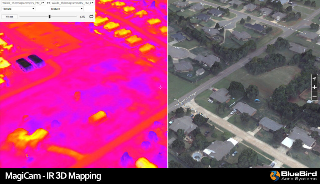
In defense applications, MagiCam provides valuable 3D and tactical information for combat units and facilitates target positioning for smart munitions. It enables near real-time terrain and hostile situational awareness, aiding informed decision-making. The system also contributes to battle damage assessment (BDA), operational mission planning, high-accuracy measurement tools, and mission preparation 3D databases. Optional inclusion of IR thermal mapping adds versatility for night operations.
The MagiCam payload* features impressive specifications, including a 103 MP sensor, a 5-look projected image footprint, nadir imaging capabilities, an onboard processing computer, and high-speed storage in an amazing weight of 1500 grams. It supports geo-tagging and includes a calibrated lens for precise data processing.
BlueBird presents a comprehensive tactical mapping solution with MagiCam, combining high-resolution 2D and 3D mapping capabilities with autonomous, simple and undetected operation. The system excels in providing extensive coverage per flight hour, ensuring efficient mapping operations. Equipped with powerful intelligence analysis tools**, MagiCam enables advanced data analysis and interpretation, further enhancing its value.
*Payload developed by WaldoAir from Panama City Florida. WaldoAir is the main supplier of 3D mapping payload for FEMA and the Civil Air Patrol.
**Processing of images, creation of 3D database and the smart tools supported by Skyline Software Inc. software and are used by the US army geospatial centers and many other organizations around the world.
“We are thrilled to introduce MagiCam, a game-changing tactical 3D mapping solution,” says Ronen Nadir, CEO & Founder at BlueBird. “This innovative system redefines the boundaries of large area mapping, delivering exceptional 3D products, accuracy, efficiency and capabilities never seen before. MagiCam’s integration with our WanderB-VTOL UAV further enhances its capabilities, providing customers with an unparalleled solution for their mapping needs.”
About BlueBird Aero Systems:
BlueBird Aero Systems is a major player in the tactical unmanned aerial systems industry, specializing in the design and production of mini and small tactical UAS with Vertical Takeoff and Landing (VTOL) capabilities as well as Loitering Munition Systems. Bluebird’s advanced solutions are combat proven since 2006 and are ideal for supporting open and urban scenarios, and suitable for military ISTAR, peacekeeping, border security, disaster management, law enforcement, S&R, and commercial applications.
About Skyline Software Inc.
Skyline Software Systems’ Photomesh module is a powerful and scalable 3D Reconstruction engine. It processes large amounts of images from MagiCam systems using parallel computing. It generates high-quality 3D Textured Mesh Models and other products like True-Ortho, Colorized Point Cloud, DSM, DTM, etc. Along with TerraExplorer as an optimal 3D Viewer for measurements, analytics, mission planning, and GIS integration, capabilities such as change detection, line-of-sight analysis, and sensor cross-correlation (day / thermal) create the ultimate common operating picture for all tactical and operational needs.
About WaldoAir
WaldoAir was formed in 2013 specifically to address the growing need of 3D imagery supporting Smart Cities, and SG applications. The founders of Waldo have a distinguished background in sensor system development and operations dating back to the original development of what would eventually become the Applanix DSS and most recently the Google GeoPod.